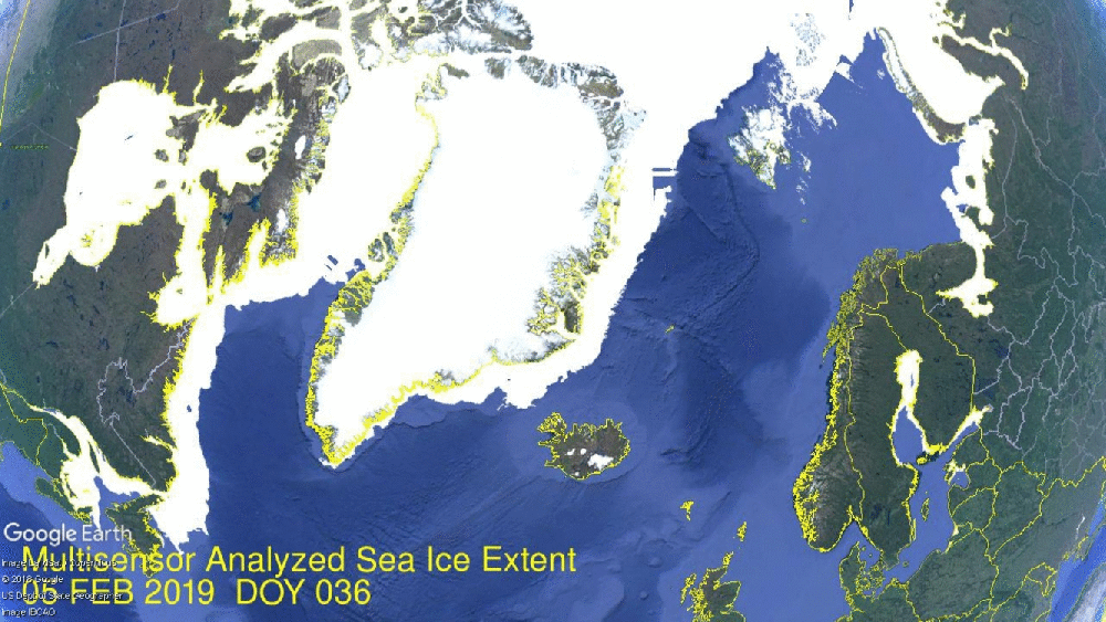
Sea Ice Extends on the Atlantic Side: The animation above shows the last two weeks on the Atlantic side, with Kara achieving its annual maximum and Barents growing ice up to 86% of its max last March. In the upper right the ice solidifies down to Svalbard and fast ice forms along the mainland. On the left, Baffin ice thickens along the Labrador coast and a large mass forms along Newfoundland. The Gulf of St. Lawrence is nearly iced over. Below is the ice recovery on the Pacific side.

Bering on the right retreats and then recovers to stay at 95% of its 2018 maximum. Meanwhile Okhotsk on the left shows a surge of sea ice, gaining almost 400k km2 over these two weeks. Bering is well below the 12 year average, while Okhotsk has already passed its 2018 maximum and is 22% above the 12 year average.
The graph below shows February progress in ice extent recovery.

2019 ice extents declined slightly to start the month, then grew rapidly in the last two weeks to nearly match the 12-year average (2007 to 2018 inclusive). SII lags MASIE by 100k km2 at this date. 2019 is presently matching 2017, and has nearly 500k km2 more ice than 2018.
Interestingly, 2019 extent has already surpassed 14.75 M km2, the 2018 maximum reached on day 74. Note in the graph that 2017 peaks on day 53, the maximum extent that year. The average maximum is 15.07 M km2 on day 62, so 2019 has 11 days more to reach that level.

The table below shows the distribution of ice in the various Arctic basins.
| Region | 2019051 | Day 051 Average | 2019-Ave. | 2018051 | 2019-2018 |
| (0) Northern_Hemisphere | 14785938 | 14847524 | -61587 | 14303929 | 482009 |
| (1) Beaufort_Sea | 1070498 | 1070200 | 297 | 1070445 | 53 |
| (2) Chukchi_Sea | 965972 | 964755 | 1217 | 955104 | 10868 |
| (3) East_Siberian_Sea | 1087137 | 1087133 | 4 | 1087120 | 18 |
| (4) Laptev_Sea | 897845 | 897842 | 3 | 897845 | 0 |
| (5) Kara_Sea | 934970 | 920340 | 14629 | 917650 | 17319 |
| (6) Barents_Sea | 685511 | 606250 | 79261 | 537870 | 147642 |
| (7) Greenland_Sea | 564543 | 619655 | -55112 | 440813 | 123730 |
| (8) Baffin_Bay_Gulf_of_St._Lawrence | 1527391 | 1487134 | 40257 | 1731868 | -204477 |
| (9) Canadian_Archipelago | 853337 | 853036 | 302 | 853109 | 229 |
| (10) Hudson_Bay | 1260903 | 1260717 | 186 | 1260838 | 66 |
| (11) Central_Arctic | 3239858 | 3210652 | 29205 | 3154998 | 84860 |
| (12) Bering_Sea | 428805 | 724586 | -295781 | 211528 | 217277 |
| (13) Baltic_Sea | 54788 | 107524 | -52735 | 85965 | -31177 |
| (14) Sea_of_Okhotsk | 1194028 | 977205 | 216823 | 1059514 | 134514 |
The table shows how 2019 is matching the 12-year average almost everywhere. Barents has edged 13% ahead of average, and is much higher than last year. The slight overall deficit is mainly due to Bering ice down nearly 300k km2 to average, only partly offset by the surplus in Okhotsk and Central Arctic.

Footnote: At his AER blog Arctic Oscillation and Polar Vortex Analysis and Forecasts Dr. Judah Cohen writes on February 18 regarding this cold winter in the Arctic and NH. Excerpts in italics with my bolds.

Figure ii. Analysis of surface temperature anomalies ffrom 18 November 2018 until 15 February 2019. Taken from https://www.esrl.noaa.gov/psd/map/clim/glbcir_rnl.shtml.
This winter once again we had what I would refer to as a highly anomalous stratospheric PV split but not as extreme as 2009 and the temperature anomalies for the winter, or certainly post the PV split are probably not going to look that terribly different from 2009. The largest negative departures are likely to be in western North America and Siberia. I will show the winter temperature anomalies with the AER forecast posted in November and from the dynamical models but for today's blog a quick and dirty surface temperature plot from NOAA will do (Figure ii). The most striking temperature anomalies are what I would consider as a couplet – strong positive temperature anomalies in the Barents-Kara Seas and strong negative temperature anomalies in Siberia. This temperature couplet has been the most consistent feature of Northern Hemisphere winters of probably the past 15-20 years. This gets to the heart of the debate does Arctic change influence mid-latitude weather. I think I have been as emphatic as anybody on the planet that the answer is yes, and this winter will only strengthen my conviction. The other continental region that is likely to have negative departures is Canada and since the PV spit the largest negative departures are centered in Western Canada.

Since November, I have consistently stated that the largest sea ice anomalies and consequently the largest positive atmospheric temperature anomalies will be in the Barents-Kara Seas. I have also discussed how surprising I find it how cold the remainder of the Arctic has been this winter. As an example, I show in Figure iii the global temperature anomalies from yesterday February 17th the https://climatereanalyzer.org/. The Arctic positive temperature departure is 0.9°C equal to the NH and global temperature departure. This is a far cry from recent winters when the Arctic has warmed at a rate six times the rate of the remainder of the globe. Ironically the globe is currently experiencing Antarctic amplification and not Arctic amplification contrary to expectations.
My thoughts about March haven't changed much since last week. The stratosphere has worked well as a predictor of North American temperature anomalies and for the most part they seem to support a continuation of cold temperatures focused in western North America. Despite this it is my own experience that cold air focused in western North America tends to shift east with time especially in the late winter. Therefore, based on this empirical observation I was expecting possibly a return to more sustained cold in the eastern US as winter winds down. This is now being predicted by both the GFS and ECMWF models. It is my experience that models may be too quick to predict a pattern change but they are often correct in anticipating the pattern change. But even assuming the eastern US turns colder, will it persist for more than just a few days? My confidence in such an outcome would increase if the Arctic finally warms something that has not really happened so far this winter.


from Climate Change Skeptic Blogs via hj on Inoreader https://ift.tt/2BWVA75


No comments:
Post a Comment